Daftar wilayah di Alabama

Negara bagian Alabama memiliki 67 county. Yang tertua adalah Washington County (dibentuk pada 4 Juni 1800) dan yang termuda adalah Houston County (dibentuk pada 9 Februari 1903).
| Wilayah |
Kode FIPS[1] | No. Lisensi [2] |
Didirikan[3] | Asal[3] | Etimologi[4] | Penduduk[5] | Luas[5] | Peta | |
|---|---|---|---|---|---|---|---|---|---|
| Wilayah Autauga | 001 | Prattville | 4 | 1818 | Formed from Montgomery County | Autauga Creek | 49.730 | 596 mi² (1,544 km²) | 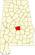
|
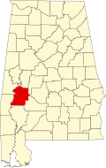
| Wilayah Baldwin | 003 | Bay Minette | 5 | 1809 | Formed from Washington County and West Florida | Abraham Baldwin (1754–1807), legislator dari Georgia | 169.162 | 1.596 sq mi (4.134 km2) |

|
| Wilayah Barbour | 005 | Clayton | 6 | 1832 | Formed from Pike County | James Barbour (1775–1842), Gubernur Virginia dan Senator | 28.171 | 885 sq mi (2.292 km2) |

|
| Wilayah Bibb | 007 | Centreville | 7 | 1818 | Formed from Montgomery County (as Cahawba County) | William Wyatt Bibb (1781–1820), Gubernur Alabama | 21.482 | 623 sq mi (1.614 km2) |

|
| Wilayah Blount | 009 | Oneonta | 8 | 1818 | Formed from Montgomery County and Indian territories | Willie Blount (1768–1835), Gubernur Tennessee. | 56.436 | 646 sq mi (1.673 km2) |

|
| Wilayah Bullock | 011 | Union Springs | 9 | 1866 | Formed from Barbour, Macon, Montgomery, and Pike Counties | Edward Bullock, colonel di Confederate States Army | 10.906 | 625 sq mi (1.619 km2) |

|
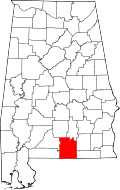
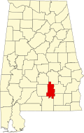
| Wilayah Butler | 013 | Greenville | 10 | 1819 | Formed from Conecuh and Monroe Counties | William Butler, captain di Perang Creek | 20.520 | 777 sq mi (2.012 km2) |
|
| Wilayah Calhoun | 015 | Anniston | 11 | 1832 | Formed from St. Clair County (as Benton County) | John C. Calhoun (1782–1850), Wakil presiden AS ke-7 | 112.903 | 608 sq mi (1.575 km2) |

|
| Wilayah Chambers | 017 | La Fayette | 12 | 1832 | Formed from Montgomery County | Henry H. Chambers (1790–1826), Senator | 35.176 | 597 sq mi (1.546 km2) |
|
| Wilayah Cherokee | 019 | Centre | 13 | 1836 | Formed from Cherokee territory | Orang Cherokee | 24.863 | 553 sq mi (1.432 km2) |

|
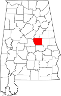
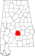
| Wilayah Chilton | 021 | Clanton | 14 | 1868 | Formed from Autauga, Bibb, Perry, and Shelby Counties (as Baker County) | William Parish Chilton (1810–1871), Hakim Alabama Supreme Court dan congressman | 41.953 | 694 sq mi (1.797 km2) |

|
| Wilayah Choctaw | 023 | Butler | 15 | 1847 | Formed from Sumter and Washington Counties | Orang Choctaw, yang tanahnya termasuk Alabama | 14.656 | 914 sq mi (2.367 km2) |

|
| Wilayah Clarke | 025 | Grove Hill | 16 | 1812 | Formed from Washington County | John Clarke, general di Perang Creek dari Georgia | 27.248 | 1.238 sq mi (3.206 km2) |

|
| Wilayah Clay | 027 | Ashland | 17 | 1866 | Formed from Randolph and Talladega Counties | Henry Clay (1777–1852), legislator dari Kentucky | 13.829 | 605 sq mi (1.567 km2) |

|
| Wilayah Cleburne | 029 | Heflin | 18 | 1866 | Formed from Calhoun, Randolph , and Talladega Counties | Patrick Cleburne (1828–1864), major general di Confederate States Army | 14.700 | 560 sq mi (1.450 km2) |

|
| Wilayah Coffee | 031 | Elba | 19 | 1841 | Formed from Dale County | John Coffee (1772–1833), pemimpin militer di Perang 1812 dan Perang Creek | 46.027 | 679 sq mi (1.759 km2) |

|
| Wilayah Colbert | 033 | Tuscumbia | 20 | 1867 | Formed from Franklin County | George Colbert dan Levi Colbert, kepala suku Chickasaw | 54.766 | 595 sq mi (1.541 km2) |

|
| Wilayah Conecuh | 035 | Evergreen | 21 | 1818 | Formed from Monroe County | Sungai Conecuh | 13.403 | 851 sq mi (2.204 km2) |

|
| Wilayah Coosa | 037 | Rockford | 22 | 1832 | Formed from Montgomery County | Sungai Coosa | 11.044 | 652 sq mi (1.689 km2) |
|
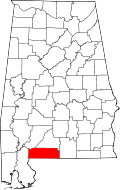
| Wilayah Covington | 039 | Andalusia | 23 | 1821 | Formed from Henry County | Leonard Covington (1768–1813), brigadier general di Perang 1812 dan Congressman | 37.234 | 1.034 sq mi (2.678 km2) |
|
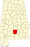
| Wilayah Crenshaw | 041 | Luverne | 24 | 1866 | Formed from Butler, Coffee, Covington, Lowndes, and Pike Counties | Anderson Crenshaw, penetap Butler County | 13.719 | 610 sq mi (1.580 km2) |
|
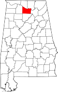
| Wilayah Cullman | 043 | Cullman | 25 | 1877 | Formed from Blount, Morgan, and Winston Counties | John G. Kullmann, pendiri ibu kota county | 80.187 | 738 sq mi (1.911 km2) |

|
| Wilayah Dale | 045 | Ozark | 26 | 1824 | Formed from Covington and Henry Counties | Samuel Dale (1772–1841), brigadier general dan legislator | 48.392 | 561 sq mi (1.453 km2) |

|
| Wilayah Dallas | 047 | Selma | 27 | 1818 | Formed from Monroe and Montgomery Counties | Alexander James Dallas (1759–1817), Secretary of Treasury | 43.945 | 981 sq mi (2.541 km2) |

|
| Wilayah DeKalb | 049 | Fort Payne | 28 | 1836 | Formed from Cherokee territory | Johann de Kalb (1721–1780), major general di Perang Revolusi Amerika | 69.014 | 778 sq mi (2.015 km2) |

|
| Wilayah Elmore | 051 | Wetumpka | 29 | 1866 | Formed from Autauga, Coosa, Montgomery, and Tallapoosa Counties | John Archer Elmore, veteran Perang Revolusi Amerika | 75.688 | 621 sq mi (1.608 km2) |

|
| Wilayah Escambia | 053 | Brewton | 30 | 1868 | Formed from Baldwin and Conecuh Counties | Escambia Creek | 37.849 | 947 sq mi (2.453 km2) |
|
| Wilayah Etowah | 055 | Gadsden | 31 | 1866 | Formed from Blount, Calhoun, Cherokee, DeKalb, Marshall, and St. Clair Counties (as Baine County) | Etowah Indian Mounds | 103.362 | 535 sq mi (1.386 km2) |

|
| Wilayah Fayette | 057 | Fayette | 32 | 1824 | Formed from Marion, Pickens, Tuscaloosa, and Walker Counties | Marquis de La Fayette (1757–1834), komandan Perang Revolusi Amerika | 18.005 | 628 sq mi (1.627 km2) |

|
| Wilayah Franklin | 059 | Russellville | 33 | 1818 | Formed from Cherokee territory | Benjamin Franklin (1706–1790) | 30.847 | 636 sq mi (1.647 km2) |

|
| Wilayah Geneva | 061 | Geneva | 34 | 1868 | Formed from Coffee, Dale, and Henry Counties | Geneva, New York | 25.868 | 576 sq mi (1.492 km2) |

|
| Wilayah Greene | 063 | Eutaw | 35 | 1819 | Formed from Marengo and Tuscaloosa Counties | Nathanael Greene (1742–1786), jenderal Perang Revolusi Amerika | 9.374 | 646 sq mi (1.673 km2) |

|
| Wilayah Hale | 065 | Greensboro | 36 | 1867 | Formed from Greene, Marengo, Perry, and Tuscaloosa Counties | Stephen F. Hale, letnan kolonel di Confederate States Army | 18.236 | 644 sq mi (1.668 km2) |

|
| Wilayah Henry | 067 | Abbeville | 37 | 1819 | Formed from Conecuh County | Patrick Henry (1736–1799), pahlawan Perang Revolusi Amerika dan Gubernur Virginia | 16.706 | 562 sq mi (1.456 km2) |
|
| Wilayah Houston | 069 | Dothan | 38 | 1903 | Formed from Dale, Geneva, and Henry Counties | George S. Houston (1811–1879), Gubernur Alabama dan Congressman | 95.660 | 580 sq mi (1.502 km2) |

|
| Wilayah Jackson | 071 | Scottsboro | 39 | 1819 | Formed from Cherokee territory | Andrew Jackson (1767–1845), Presiden AS | 53.745 | 1.079 sq mi (2.795 km2) |

|
| Wilayah Jefferson | 073 | Birmingham | 1 | 1819 | Formed from Blount County | Thomas Jefferson (1743&ndash1826), Presiden AS | 656.700 | 1.113 sq mi (2.883 km2) |

|
| Wilayah Lamar | 075 | Vernon | 40 | 1867 | Formed from Fayette and Marion Counties (as Jones County) | Lucius Q. C. Lamar (1825–1893), Hakim Supreme Court | 14.548 | 605 sq mi (1.567 km2) |

|
| Wilayah Lauderdale | 077 | Florence | 41 | 1818 | Formed from Cherokee and Chickasaw territories | James Lauderdale, kolonel di Perang 1812 | 87.891 | 669 sq mi (1.733 km2) |
|
| Wilayah Lawrence | 079 | Moulton | 42 | 1818 | Formed from Cherokee territory | James Lawrence, komandan di Perang 1812 | 34.312 | 693 sq mi (1.795 km2) |

|
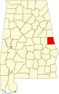
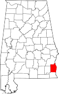
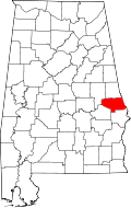
| Wilayah Lee | 081 | Opelika | 43 | 1866 | Formed from Chambers, Macon, Russell, and Tallapoosa Counties | Robert E. Lee, komoandan Confederate States Army | 125.781 | 609 sq mi (1.577 km2) |
|
| Wilayah Limestone | 083 | Athens | 44 | 1818 | Formed from Elk and Madison Counties | Limestone Creek | 72.446 | 568 sq mi (1.471 km2) |

|
| Wilayah Lowndes | 085 | Hayneville | 45 | 1830 | Formed from Butler, Dallas, and Montgomery Counties | William Lowndes, Congressman dari South Carolina | 12.759 | 718 sq mi (1.860 km2) |
|
| Wilayah Macon | 087 | Tuskegee | 46 | 1832 | Formed from Montgomery County | Nathaniel Macon, legislator dari North Carolina | 22.594 | 611 sq mi (1.582 km2) |

|
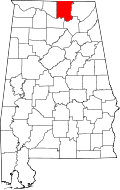
| Wilayah Madison | 089 | Huntsville | 47 | 1808 | Formed from Cherokee and Chickasaw territories | James Madison, Presiden AS | 304.307 | 805 sq mi (2.085 km2) |
|
| Wilayah Marengo | 091 | Linden | 48 | 1818 | Formed from Choctaw territory | Pertempuran Marengo | 21.842 | 977 sq mi (2.530 km2) |
|
| Wilayah Marion | 093 | Hamilton | 49 | 1818 | Formed from Tuscaloosa County | Francis Marion, pemimpin militer di Perang Revolusi Amerika | 30.165 | 741 sq mi (1.919 km2) |

|
| Wilayah Marshall | 095 | Guntersville | 50 | 1836 | Formed from >Blount and Jackson Counties and Cherokee territory | John Marshall (1755–1832), Hakim Agung Amerika Serikat 1801–1835 | 87.185 | 567 sq mi (1.469 km2) |

|
| Wilayah Mobile | 097 | Mobile | 2 | 1812 | Formed from Mobile District of West Florida after annexation into Mississippi Territory | Mobile, Alabama and Mobile Bay, on which it is located | 404.157 | 1.233 sq mi (3.193 km2) |

|
| Wilayah Monroe | 099 | Monroeville | 51 | 1815 | Formed from Creek territory | James Monroe (1758–1831), Presiden AS ke-5 1758–1831 | 23.342 | 1.026 sq mi (2.657 km2) |

|
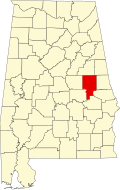
| Wilayah Montgomery | 101 | Montgomery | 3 | 1816 | Formed from Monroe County | Lemuel Montgomery, mayor di Perang Creek | 223.571 | 790 sq mi (2.046 km2) |

|
| Wilayah Morgan | 103 | Decatur | 52 | 1818 | Formed from Cherokee territory (as Cotaco County) | Daniel Morgan, Congressman | 115.237 | 582 sq mi (1.507 km2) |
|
| Wilayah Perry | 105 | Marion | 53 | 1819 | Formed from Cahawba, Dallas, Marengo, and Tuscaloosa Counties | Oliver Hazard Perry, komandan di Perang 1812 | 11.186 | 719 sq mi (1.862 km2) |

|
| Wilayah Pickens | 107 | Carrollton | 54 | 1820 | Formed from Tuscaloosa County | Andrew Pickens atau Israel Pickens | 20.133 | 881 sq mi (2.282 km2) |

|
| Wilayah Pike | 109 | Troy | 55 | 1821 | Formed from Henry and Montgomery Counties | Zebulon Pike, penjelajah dan komandan di Perang 1812 | 29.620 | 671 sq mi (1.738 km2) |

|
| Wilayah Randolph | 111 | Wedowee | 56 | 1832 | Formed from St. Clair and Shelby Counties | John Randolph, Senator dari Virginia | 22.673 | 581 sq mi (1.505 km2) |

|
| Wilayah Russell | 113 | Phenix City | 57 | 1832 | Formed from Montgomery and Pike Counties | Gilbert Russell, komandan di Perang Creek | 50.085 | 641 sq mi (1.660 km2) |

|
| Wilayah St. Clair | 115 | Ashville and Pell City | 59 | 1818 | Formed from Shelby County | Arthur St. Clair, presiden Continental Congress | 75.232 | 634 sq mi (1.642 km2) |

|
| Wilayah Shelby | 117 | Columbiana | 58 | 1818 | Formed from Montgomery County | Isaac Shelby, Gubernur Kentucky | 178.182 | 795 sq mi (2.059 km2) |

|
| Wilayah Sumter | 119 | Livingston | 60 | 1832 | Formed from Choctaw territory | Thomas Sumter, legislator | 13.606 | 905 sq mi (2.344 km2) |

|
| Wilayah Talladega | 121 | Talladega | 61 | 1832 | Formed from St. Clair and Shelby Counties | Talatigi, nama Creek yang berarti "kota perbatasan" | 80.271 | 740 sq mi (1.917 km2) |

|
| Wilayah Tallapoosa | 123 | Dadeville | 62 | 1832 | Formed from Montgomery and Shelby Counties | Sungai Tallapoosa | 41.010 | 718 sq mi (1.860 km2) |
|
| Wilayah Tuscaloosa | 125 | Tuscaloosa | 63 | 1818 | Formed from Montgomery County and Choctaw territory | Sungai Tuscaloosa | 171.159 | 1.324 sq mi (3.429 km2) |

|
| Wilayah Walker | 127 | Jasper | 64 | 1823 | Formed from Blount, Jefferson, and Tuscaloosa Counties | John Williams Walker, Senator dari Alabama | 70.034 | 794 sq mi (2.056 km2) |

|
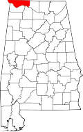
| Wilayah Washington | 129 | Chatom | 65 | 1800 | Formed from Adams and Pickering Counties of Mississippi Territory | George Washington, Presiden AS | 17.651 | 1.081 sq mi (2.800 km2) |

|
| Wilayah Wilcox | 131 | Camden | 66 | 1819 | Formed from Dallas and Monroe Counties | Joseph Wilcox, letnan di Perang Creek | 12.911 | 889 sq mi (2.302 km2) |

|
| Wilayah Winston | 133 | Double Springs | 67 | 1850 | Formed from Walker County (as Hancock County) | John A. Winston, Gubernur Alabama | 24.634 | 614 sq mi (1.590 km2) |

|
Bekas
- Baine County (dari nama David W. Baine), diubah menjadi Etowah County pada 1868
- Baker County (dari nama Alfred Baker, seorang pemilik tanah), diubah menjadi Chilton County pada 1874
- Benton County, (dari nama Thomas Hart Benton) diubah menjadi Calhoun County, dari nama John C. Calhoun dari South Carolina pada 1858.
- Cahawba County, untuk mantan ibu kota Cahawba, diubah menjadi Bibb County pada 1820
- Cotaco County (dari nama Cotaco Creek), diubah menjadi Morgan County pada 1821
- Elk County (dari nama Sungai Elk), dulunya bagian dari Houston County (dari nama John Houstoun), diubah menjadi Lauderdale County dan Limestone County pada 1818
- Hancock County (dari nama John Hancock), diubah menjadi Winston County pada 1858
- Jones County (dari nama Josiah Jones, politikus lokal), dinamai kembali menjadi Covington County pada 1868 setelah Jones menolak kehormatan tersebut.
- Jones County (dari nama E. P. Jones), dulunya Sanford County (dari nama H. C. Sanford), lalu diubah menjadi Lamar County pada 1877
Fiktif
- Aurora County, dalam buku-buku Deborah Wiles.
- Beechum County, dalam film My Cousin Vinny.
- Greenbow County, dalam film Forrest Gump, berbeda dari novelnya yang mencantumkan Mobile.
- Maycomb County, dalam buku Harper Lee yang berjudul To Kill a Mockingbird.
- Pearl County, dalam buku William March yang berjudul Looking Glass.
Referensi
- "CountyState.info Alabama". Official County Websites. Diakses tanggal 2007-09-13. - official sites
- ^ "EPA County FIPS Code Listing". EPA.gov. Diakses tanggal 2008-02-23.
- ^ Nicholson, David. "Alabama License Plates, 1969-present". License Plates of North America, 1969–present. Diakses tanggal 2007-08-08.
- ^ a b Kesalahan pengutipan: Tanda
<ref>tidak sah; tidak ditemukan teks untuk ref bernamaNACO - ^ Foscue, Virginia O. (1989) Place Names in Alabama. Tuscaloosa, Alabama: University of Alabama Press. ISBN 0-8173-0410-X
- ^ a b "Alabama QuickFacts from the US Census Bureau". State & County QuickFacts. Diakses tanggal 2007-12-11.[pranala nonaktif permanen]
Lihat pula
Konten ini disalin dari wikipedia, mohon digunakan dengan bijak.

