Bílá Lhota
Bílá Lhota | |
|---|---|
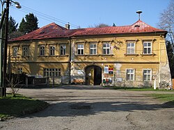 Bílá Lhota Castle, now the municipal office | |
 Bendera  Lambang kebesaran | |
 Bílá Lhota Location in the Czech Republic | |
| Koordinat: 49°42′34″N 16°58′30″E / 49.70944°N 16.97500°E | |
| Country | |
| Region | Olomouc |
| District | Olomouc |
| First mentioned | 1350 |
| Luas | |
| • Total | 18,22 km2 (703 sq mi) |
| Ketinggian | 395 m (1,296 ft) |
| Populasi (2022-01-01)[1] | |
| • Total | 1.152 |
| • Kepadatan | 0,63/km2 (1,6/sq mi) |
| Zona waktu | UTC+1 (CET) |
| • Musim panas (DST) | UTC+2 (CEST) |
| Postal codes | 783 21, 783 24 |
| Situs web | www |
Bílá Lhota (Jerman: Weissöhlhütten) adalah sebuah kotamadya dan desa di Distrik Olomouc di Wilayah Olomouc, Ceko. Ini memiliki sekitar 1.200 penduduk.
Referensi
| Basis data pengawasan otoritas: Nasional |
|---|
Artikel bertopik umum ini adalah sebuah rintisan. Anda dapat membantu Wikipedia dengan mengembangkannya. Jika Anda melihat halaman yang menggunakan templat {{stub}} ini, mohon gantikan dengan templat rintisan yang lebih spesifik. |
Konten ini disalin dari wikipedia, mohon digunakan dengan bijak.

