Al-Sumayriyya
al-Sumayriyya
السُميريه Someleria, Katasir | |
|---|---|
Bekas desa | |
 Akuaduk di al-Sumayriyya | |
 1870s map 1870s map  1940s map 1940s map modern map modern map  1940s with modern overlay map 1940s with modern overlay mapSerangkaian peta historis kawasan sektiaran Al-Sumayriyya (klik tombol) | |
  al-Sumayriyya Letak di Mandat Palestina | |
| Koordinat: 32°58′22″N 35°05′36″E / 32.97278°N 35.09333°E | |
| Grid Palestina | 159/264 |
| Entitas geopolitik | Mandat Palestina |
| Subdistrik | Akko |
| Tanggal pengosongan | 14 Mei 1948[3] |
| Luas | |
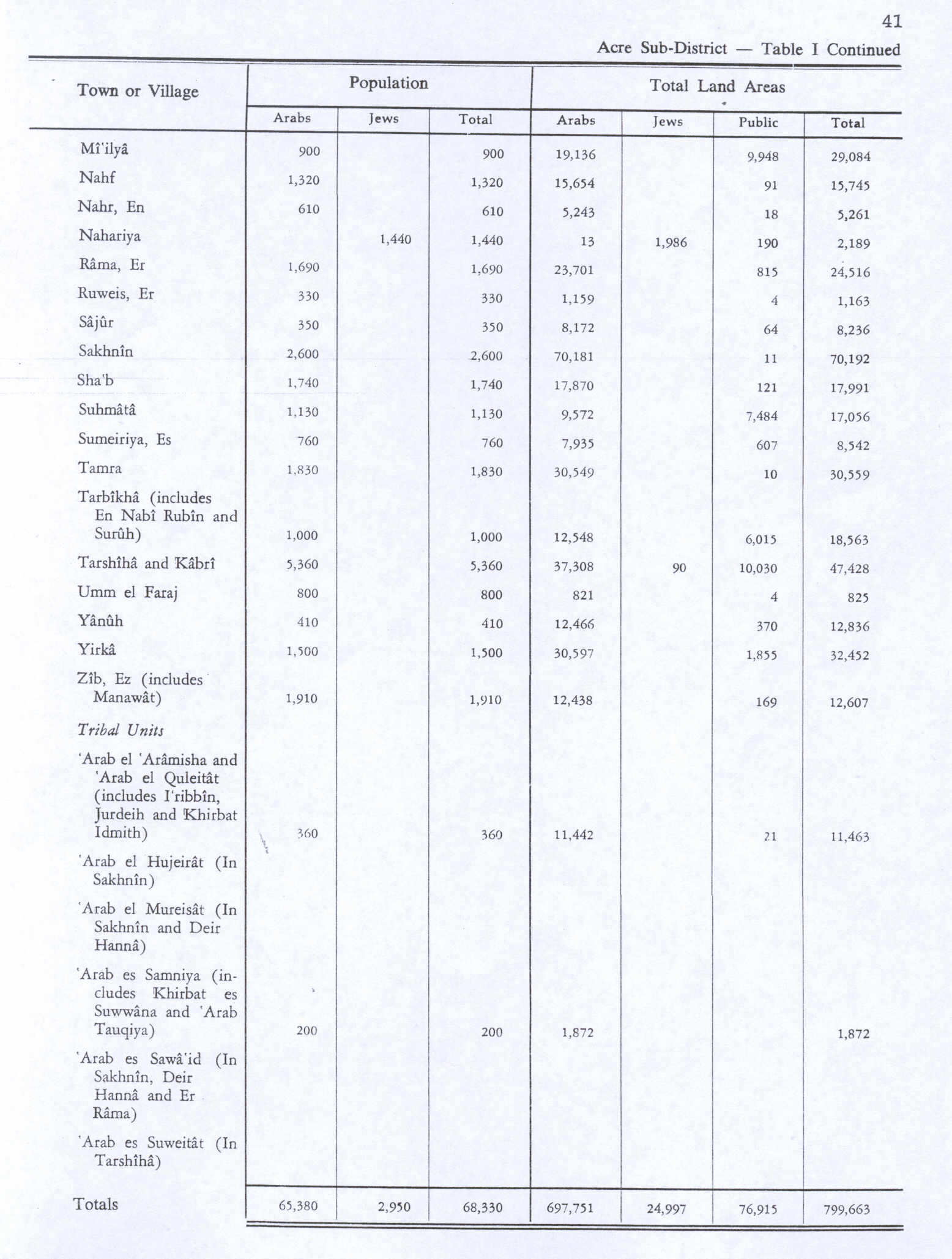
| • Total | 8,542 dunams (0,8.542 ha or 2,111 acre) |
| Populasi (1945) | |
| • Total | 760[1][2] |
| Sebab pengosongan | Serangan militer oleh pasukan Yishuv |
| Wilayah saat ini | Regba, Lohamei HaGeta'ot,[4][5] Shomrat[5] |
Al-Sumayriyya (Arab: السُميريه, Katasir pada zaman Kanaan, Someleria pada masa kekuasaan pasukan Salib), adalah sebuah desa Palestina yang bejarak enam kilometer dari utara Akko yang dikosongkan seterlah direbut oleh Pasukan Pertahanan Israel pada Perang Arab-Israel 1948.[6] Reruntuhan desa tersebut kini berada di pinggiran moshav Israel Regba.
Referensi
- ^ Department of Statistics, 1945, p. 5
- ^ a b Government of Palestine, Department of Statistics. Village Statistics, April, 1945. Quoted in Hadawi, 1970, p. 41
- ^ Morris, 2004, p.xvii, village #87. Also gives cause of depopulation
- ^ Morris, 2004, p. xxi, settlement #53. January 1949
- ^ a b Khalidi, 1992, p. 31
- ^ Welcome to Al-Sumayriyya, Palestine Remembered, diarsipkan dari asli tanggal 2008-05-16, diakses tanggal 2007-12-03
Daftar pustaka
- Barag, Dan (1979). "A new source concerning the ultimate borders of the Latin Kingdom of Jerusalem". Israel Exploration Journal. 29 (3/4): 197–217. JSTOR 27925726.
- Barron, J. B., ed. (1923). Palestine: Report and General Abstracts of the Census of 1922. Government of Palestine.
- Conder, C.R.; Kitchener, H.H. (1881). The Survey of Western Palestine: Memoirs of the Topography, Orography, Hydrography, and Archaeology. Vol. 1. London: Committee of the Palestine Exploration Fund.
- Department of Statistics (1945). Village Statistics, April, 1945. Government of Palestine.
- Guérin, V. (1880). Description Géographique Historique et Archéologique de la Palestine (dalam bahasa Prancis). Vol. 3: Galilee, pt. 2. Paris: L'Imprimerie Nationale.
- Hadawi, S. (1970). Village Statistics of 1945: A Classification of Land and Area ownership in Palestine. Palestine Liberation Organization Research Center. Diarsipkan dari asli tanggal 2018-12-08. Diakses tanggal 2009-07-15.
- Karmon, Y. (1960). "An Analysis of Jacotin's Map of Palestine" (PDF). Israel Exploration Journal. 10 (3, 4): 155–173, 244–253. Diarsipkan dari asli (PDF) tanggal 2017-12-01. Diakses tanggal 2015-04-24.
- Khalidi, W. (1992). All That Remains: The Palestinian Villages Occupied and Depopulated by Israel in 1948. Washington D.C.: Institute for Palestine Studies. ISBN 0-88728-224-5.
- Mills, E., ed. (1932). Census of Palestine 1931. Population of Villages, Towns and Administrative Areas. Jerusalem: Government of Palestine.
- Morris, B. (2004). The Birth of the Palestinian Refugee Problem Revisited. Cambridge University Press. ISBN 978-0-521-00967-6.(pp. 229,252253,314,347,350,376,380,381)
- Palmer, E.H. (1881). The Survey of Western Palestine: Arabic and English Name Lists Collected During the Survey by Lieutenants Conder and Kitchener, R. E. Transliterated and Explained by E.H. Palmer. Committee of the Palestine Exploration Fund.
- Pococke, R. (1745). A description of the East, and some other countries. Vol. 2. London: Printed for the author, by W. Bowyer. (Pococke, 1745, vol 2, p. 54; cited in Pringle, 2009, p. 233
- Pringle, D. (1997). Secular buildings in the Crusader Kingdom of Jerusalem: an archaeological Gazetter. Cambridge University Press. ISBN 9780521460101.
- Pringle, D. (1998). The Churches of the Crusader Kingdom of Jerusalem: L-Z (excluding Tyre). Vol. II. Cambridge University Press. ISBN 0-521-39037-0.
- Pringle, D. (2009). The Churches of the Crusader Kingdom of Jerusalem: The cities of Acre and Tyre with Addenda and Corrigenda to Volumes I-III. Vol. IV. Cambridge University Press. ISBN 978-0-521-85148-0. p. 233
- Raynaud, G., ed. (1887). Les gestes des Chiprois: recueil de chroniques françaises écrites en Orient au XIIIe & XVIe ... (dalam bahasa Prancis). Vol. 5. Geneve: J.G. Fick.
- Rhode, H. (1979). Administration and Population of the Sancak of Safed in the Sixteenth Century. Columbia University. Diarsipkan dari asli tanggal 2020-03-01. Diakses tanggal 2017-12-28.
- Röhricht, R. (1887). "Studien zur mittelalterlichen Geographie und Topographie Syriens". Zeitschrift des Deutschen Palästina-Vereins. 10: 195–344. p. 251
- Röhricht, R. (1893). (RRH) Regesta regni Hierosolymitani (MXCVII-MCCXCI) (dalam bahasa Latin). Berlin: Libraria Academica Wageriana.
- Schumacher, G. (1888). "Population list of the Liwa of Akka". Quarterly Statement - Palestine Exploration Fund. 20: 169–191.
- Tal, D. (2004). War in Palestine, 1948: Strategy and Diplomacy. Routledge. ISBN 0-7146-5275-X.
Pranala luar
- Welcome To al-Sumayriyya
- al-Sumayriyya, Zochrot
- Survey of Western Palestine, Map 3: IAA, Wikimedia commons
- Al-Sumayriyya at Khalil Sakakini Cultural Center
- Al-Sumauriyya, Dr. Moslih Kanaaneh
- Tour to Alsumeriyya, Umar Ighbariyyeh, 25.4.2009 Zochrot
| Basis data pengawasan otoritas: Nasional |
|---|

 | Artikel bertopik Israel ini adalah sebuah rintisan. Anda dapat membantu Wikipedia dengan mengembangkannya. |
Konten ini disalin dari wikipedia, mohon digunakan dengan bijak.